

Colorado Plateau
Largest Deserts of the World


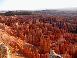
Colorado Plateau
The Colorado Plateau, also known as the Colorado Plateau Province, is a physiographic region of the Intermontane Plateaus, roughly centered on the Four Corners region of the southwestern United States. The province covers an area of 337,000 km2 (130,000 mi2) within western Colorado, northwestern New Mexico, southern and eastern Utah, and northern Arizona. About 90% of the area is drained by the Colorado River and its main tributaries: the Green, San Juan, and Little Colorado.The Colorado Plateau is largely made up of high desert, with scattered areas of forests. In the southwest corner of the Colorado Plateau lies the Grand Canyon of the Colorado River. Much of the Plateaus landscape is related, in both appearance and geologic history, to the Grand Canyon. The nickname Red Rock Country suggests the brightly colored rock left bare to the view by dryness and erosion. Domes, hoodoos, fins, reefs, goblins, river narrows, natural bridges, and slot canyons are only some of the additional features typical of the Plateau.
The Colorado Plateau has the greatest concentration of U.S. National Park Service (NPS) units in the country. Among its ten National Parks are Grand Canyon, Zion, Bryce Canyon, Capitol Reef, Canyonlands, Arches, Mesa Verde, and Petrified Forest. Among its 17 National Monuments are Dinosaur, Hovenweep, Wupatki, Sunset Crater Volcano, Grand Staircase Escalante, Natural Bridges, Canyons of the Ancients, and Colorado.
 Dasht e Lut
 Antarctica
 Kara Kum Desert Uzbekistan Turkmenistan
 Gibson Desert
 Kalahari Desert Southern Africa
 Arabian Desert peninsula
 Sahara Desert North Africa
 Gobi Desert Mongolia
 Great Victoria Desert Australia
 Chihuahuan Desert Mexico
 Patagonia Desert Argentina
 Sonoran Desert
 Test your English Language
  Best types of nuts for your health
 Stress Management Tips
 Benefits of Mangoes
 Benefits of Cherry
 Xmas Games
 Success Tips For Life
 Top Most Powerful Armies In The World The Lifecycle of a Butterfly Controversial Trivia of Cartoon Characters World Wonders Best Valentines Day Gifts Best Wedding Dresses in the World Weird and wild cutting edge Security Threats
 Astrology Amazing Pakistani Mehndi Designs Looney Tunes Characters With Mental Disorders Lotus Flower Tattoo Loudest College Football Stadiums